
Start with our video overview:

The Forma Urbis Romae was a marble map of the city of Rome created during the reign of Emperor Septimius Severus (193-211 CE). Although only fragments survive today, it remains one of the most extraordinary records of Rome’s urban design and architecture.
Roman mapping and urban planning dates back to the first century CE. Under Augustus, a map of the world was carved in marble on the Porticus Vipsania. The Forma Urbis, however, was a much more ambitious project – a detailed and monumental depiction of Rome at its height. The map measured roughly 13 by 18 meters and was carved on 150 slabs of Proconnesian marble at a scale of 1:240. While the map displayed Rome’s streets, temples, warehouses, and even private homes, its sheer size made it impractical for much detail. Instead, it functioned as a monumental representation of Rome’s urban landscape, reinforcing its status as the capital of a vast empire.
The map was mounted on an interior wall of the Temple of Peace within the Forum of Vespasian, which had been rebuilt after a fire in 192 CE. The slabs were attached with metal clamps and dowel rods, and major features were labeled in red paint. The map was oriented with the south at the top, the reverse of most modern maps. Over time, the monument fell into ruin. Much of the marble was stripped for building materials during the Middle Ages, leaving only a fraction of the original panels.
In 1562, fragments of the Forma Urbis were rediscovered at the base of the original wall, sparking centuries of scholarly study. Archaeologists and historians have worked to piece the fragments together, using identifiable features such as the Colosseum and Circus Maximus to reconstruct parts of the city’s layout.
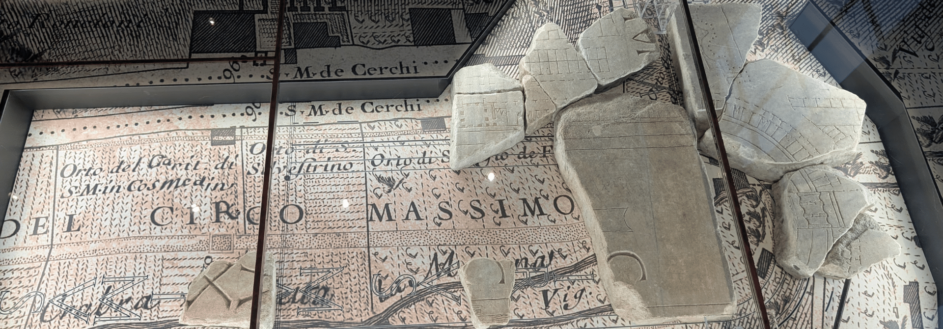
Today, the surviving fragments are displayed at the Museo della Forma Urbis Romae on the Caelian Hill. The museum presents the ancient pieces alongside the 1748 Nolli Plan of Rome, creating a dialogue between the ancient and early modern city. Through this display, visitors can visualize Imperial Rome’s vast and intricate urban landscape, from its monumental baths and temples to the densely built neighborhoods that once filled the world’s most powerful city.
Bibliography:
- Balmer, Crispian. (2024). “Monumental Ancient Map Re-emerges in New Rome Museum.” Reuters. https://www.reuters.com/lifestyle/monumental-ancient-map-re-emerges-new-rome-museum-2024-01-11/
- “Museo Della Forma Urbis.” Turismo Roma. www.turismoroma.it/en/places/museo-della-forma-urbis
- Taub, Liba. (1993). “The Historical Function of the ‘Forma Urbis Romae.’” Imago Mundi, 45, 9–19. http://www.jstor.org/stable/1151156

This content is brought to you by The American Institute for Roman Culture, a 501(C)3 US Non-Profit Organization.
Please support our mission to aid learning and understanding of ancient Rome through free-to-access content by donating today.
Cite This Page
Cite this page as: Darius Arya, The American Institute for Roman Culture, “Map of Ancient Rome (Forma Urbis Romae),” Ancient Rome Live. Last modified 10/26/2025. https://ancientromelive.org/map-of-ancient-rome-forma-urbis-romae
License
Created by The American Institute of Roman Culture, published on 10/26/2025 under the following license: Creative Commons: Attribution-NonCommercial-ShareAlike. This license lets others remix, tweak, and build upon this content non-commercially, as long as they credit the author and license their new creations under the identical terms. Please note that content linked from this page may have different licensing terms.
